The Majestic Volcano: Haleakalā & Upcountry
Focused, affordable—crater, cinder cones, and pastoral Maui

Written by a Local Expert
Jade KawanuiFor those fascinated by the raw power of geology or seeking a more focused and affordable helicopter experience, this tour is a perfect choice. It forgoes the coastal rainforests to concentrate entirely on the magnificent centerpiece of the island: the dormant volcano of Haleakalā.
The Direct Ascent
This flight is a direct and dramatic journey to the 10,023-foot summit. The ascent itself is a marvel, as you watch the landscape below transform from green pastures to the barren, rocky terrain of the volcano's upper slopes.
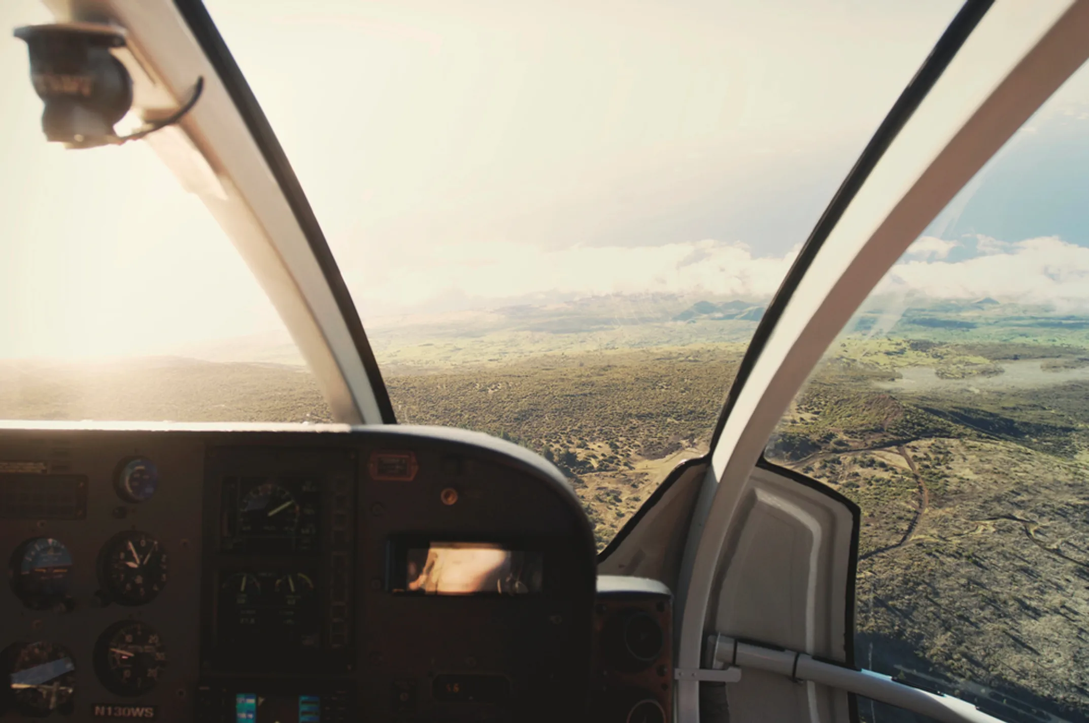
You take off from the lowlands and immediately start climbing. The helicopter gains altitude quickly. Below you, the patchwork of sugarcane fields, pineapple fields, and residential areas gives way to ranch land. The towns become smaller. The roads become less frequent. The vegetation changes from tropical to temperate. You see eucalyptus trees and ironwoods instead of palms and banyans.
As you continue climbing, the air outside becomes thinner and colder. If you're on a doors-off flight, you'll feel the temperature drop significantly. The landscape becomes increasingly barren. You're above the tree line now. The volcanic soil is visible in swaths of red and brown. There are fewer signs of human habitation. The occasional water tank or fence line is all that marks human presence.
Entering the Crater
The main event, of course, is the crater. Your pilot will guide you over the vast, moon-like expanse, providing commentary on the unique geological features. You'll get an unparalleled view of the vibrant colors of the different cinder cones, each one the result of a past eruption.
The scale is hard to comprehend until you see it from above, a massive depression carved out by erosion over eons. The crater is roughly seven miles across at its widest point and about two miles deep. The floor is relatively flat in some areas and punctuated by steep cones in others. The cones themselves can be several hundred feet tall.
Each cinder cone has its own character. Some are symmetrical and pristine, looking like they erupted yesterday. Others are weathered and eroded, their flanks scarred by gullies where rain has washed away loose material. The colors vary from cone to cone, depending on the minerals present in the ejected material. You see reds, oranges, yellows, blacks, and even purples in certain light.
The Science of Haleakalā
Your pilot will explain that Haleakalā is not extinct but dormant. Its last eruption was around 1790, which in geological terms is extremely recent. Scientists monitor the volcano continuously for signs of renewed activity. While an eruption is not expected anytime soon, the possibility always exists.
The crater itself is not actually a crater in the traditional sense, meaning it wasn't formed by a single explosive eruption. It's technically an erosional valley, carved by streams and then deepened by the collapse of the summit area. The two main valleys, Ko'olau Gap on the north and Kaupō Gap on the south, were eroded by water over hundreds of thousands of years. Eventually, the headwalls of these valleys eroded back far enough that they merged, creating the large depression we see today.
Upcountry Maui: A Different Side of Paradise
On the return journey, the flight path typically takes you over Upcountry Maui. This is a completely different side of the island, a rolling, pastoral landscape that resembles the countryside of Ireland or Northern California more than a tropical paradise.
You'll see the patchwork quilt of farms, ranches, and botanical gardens that blanket the fertile volcanic slopes of Kula. The fields are divided by lines of trees planted as windbreaks. Cattle and horses graze in fenced pastures. Nurseries grow protea flowers, which thrive in this cooler, drier climate. You can spot the distinctive shapes of jacaranda trees, which explode with purple blossoms in the spring.
This area produces much of Maui's fresh produce. The volcanic soil is incredibly fertile, and the elevation provides a temperate climate perfect for crops that won't grow at sea level. You'll see rows of vegetables, orchards of citrus and avocado, and fields of lavender. The Upcountry area is also home to many of Maui's ranches. Cattle ranching has been an important industry here since the 1800s, when King Kamehameha III brought in Mexican vaqueros to manage the herds.
The small towns of Upcountry have their own character. Makawao is visible from the air, with its false-front buildings and paniolo cowboy culture. Kula spreads across the slopes in a loose collection of properties, each with its own character. The roads wind through this area, connecting farms and homes perched on hillsides with sweeping views.
The Value of a Shorter Flight
As the shortest of the main helicopter tours, usually running 30 to 45 minutes, this is also the most budget-friendly option. It's an excellent way to experience the awe of Haleakalā without committing to the time and expense of the longer circle-island tours.
For families on a budget, or for travelers who may feel uncertain about whether they'll enjoy a helicopter ride, this shorter tour is a smart choice. It provides a significant and memorable experience without the larger investment. If you love it, you can always book a longer tour later in your trip or on a future visit.
However, it's crucial to manage expectations regarding the weather. The summit is notorious for its unpredictable conditions, and cloud cover is a real possibility at any time of day. A good tour operator will be honest about visibility before you take off. Some days, the crater is completely socked in with clouds. On those days, the tour operator may offer you the option to reschedule or to take the flight anyway with the understanding that views may be limited.
Even when clouds are present, the experience can still be worthwhile. Flying through and above the cloud layer is magical in its own right. The tops of the cinder cones poking through the clouds create an otherworldly scene. However, if your primary goal is photography and you want clear views of the crater floor, pay close attention to weather forecasts and be prepared to be flexible with your schedule.
Photographer's Insight: Shooting the Volcano
If you opt for a doors-off flight on this route, you absolutely must dress in layers. It gets incredibly cold at 10,000 feet, especially with the wind chill. A warm jacket, long pants, and even a beanie are a good idea. I've seen people shivering in shorts and t-shirts, too cold to even hold their cameras steady. Don't let that be you.
For your gear, a versatile zoom lens like a 24-70mm is ideal. It allows you to capture the vast, wide-angle shots of the entire crater and then, without having to change lenses in the windy cabin, zoom in to isolate the fascinating details and textures of the individual cinder cones and lava flows.
The lighting inside the crater can be tricky. The walls of the crater can cast shadows on portions of the floor, creating high contrast situations. If your camera has a dynamic range or HDR function, this is a good time to use it. Alternatively, shoot in RAW format so you have maximum flexibility in post-processing to recover shadow and highlight detail.
Pay attention to your composition. The crater is so vast that it can be difficult to create a sense of scale or a focal point. Look for leading lines in the lava flows or hiking trails. Use the cinder cones as anchor points in your frame. If there are clouds casting shadows on the crater floor, use those shadows to add depth and drama to your images.
Explore More Sections
ℹ️ This Tour
- Duration:30–45 min
- Cost:$$
- Best for:Geology & budget