The Forging of a New Coastline
Part II: The Story of the 2018 Eruption
Written by a Local Expert
Kalani MillerPart II: The Forging of a New Coastline: The Story of the 2018 Eruption
To truly understand the new Pohoiki, you have to understand the huge event that created it. The 2018 eruption of Kīlauea was not just another lava flow. It was one of the most significant volcanic events in Hawaiʻi in the last 200 years. An event that rewrote the map of the Puna district.
The Prelude: A System Under Pressure (April-May 2018)
For nearly a decade, Kīlauea had been erupting from two locations. The summit crater of Halemaʻumaʻu and the Puʻu ʻŌʻō vent on the East Rift Zone. But in late April 2018, scientists at the Hawaiian Volcano Observatory (HVO) detected a dramatic change. The magma system beneath Puʻu ʻŌʻō was building pressure rapidly.
On April 30, the floor of the Puʻu ʻŌʻō crater collapsed. Almost right away, the lava lake at the summit began to drain as if a plug had been pulled. Magma was on the move. Moving underground down the Lower East Rift Zone (LERZ). This underground movement triggered thousands of earthquakes. It built up to a massive magnitude 6.9 quake on May 4. The strongest to hit the island in 43 years. It shook the entire district and announced the chaos to come.
Fissure 8: A River of Fire Through Puna
On May 3, 2018, the ground in the Leilani Estates subdivision split open. The first of 24 fissures began erupting lava. For the first two weeks, the eruption was marked by relatively small flows of cooler, thicker magma. This magma had been stored in the rift zone for years, perhaps decades. But then came Fissure 8.
Around May 18, Fissure 8 tapped into a new source. A direct conduit to the much hotter, more fluid basaltic magma from Kīlauea's summit reservoir. This change in magma chemistry was the critical turning point. The eruption rate exploded. It increased by a factor of 10 to 20. Fissure 8 became a roaring fountain of lava. It shot molten rock more than 160 feet into the air. It fed a massive, fast-moving channeled river of lava that flowed relentlessly toward the sea.
This river of fire would ultimately cover 13.7 square miles. It destroyed over 700 homes and created 875 acres of new land.
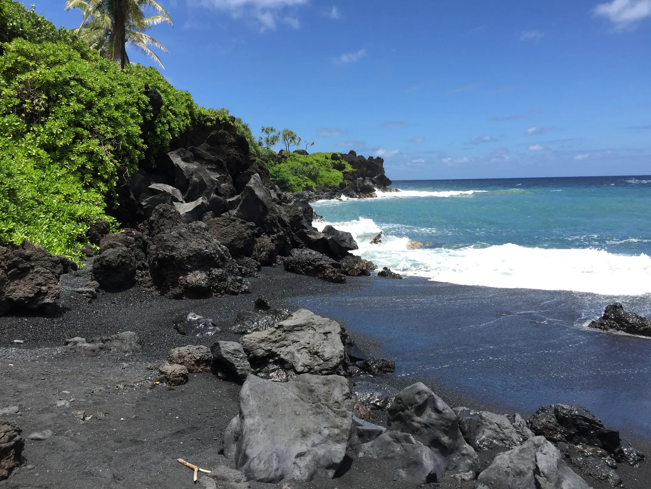
The Violent Birth of Black Sand: When Fire Meets Water
The creation of Pohoiki's black sand beach was a direct result of the violent interaction between this superheated lava and the cold Pacific Ocean. When the lava, with a temperature exceeding 2,000°F (1,093°C), poured into the sea, the extreme thermal shock caused it to shatter explosively. This process, known as a littoral explosion, instantly broke the molten rock into everything from large chunks of tephra to the fine, glassy particles that would become the new sand.
This meeting of elements was incredibly hazardous. It generated a dangerous plume known as "laze" (a mix of lava and haze). A corrosive cloud of seawater steam, hydrochloric acid, and fine volcanic glass particles that could cause severe skin, eye, and lung irritation. For weeks, this process continued. It generated an immense volume of new volcanic material just up the coast from Pohoiki Bay.
Building a Beach: The Work of Waves and Currents
The newly created sand didn't just pile up at the ocean entry. Nature immediately went to work redistributing it. The powerful longshore current, which flows parallel to the Puna coast, began to pick up the fresh volcanic sand and transport it northward. Pohoiki Bay, with its boat ramp and breakwater, acted as a natural trap for this sediment. The structures slowed the current, causing the suspended sand to drop and accumulate at an amazing rate.
The United States Geological Survey (USGS) and researchers from the University of Hawaiʻi at Hilo have studied this formation process in detail. They even used Ground Penetrating Radar (GPR) to look at the internal structure of the new beach. Their work reveals that the beach was built in distinct phases:
🌊 Phase 1: Progradation
The initial phase was a period of rapid and energetic growth. The finest-grained material from the lava-water interaction quickly filled in the area known as Second Bay. It pushed the shoreline seaward in a process called progradation.
🏖️ Phase 2: Accumulation
The growth continued, though at a slower pace. Migrating dunes built upon the initial beach face.
⚖️ Current Phase
Today, the beach is in a more stable but still dynamic phase. It continues to be shaped by daily tides and the powerful seasonal swells that can rework the sediment.
The story of Pohoiki's creation is a perfect example of how specific conditions lead to dramatic changes. It wasn't just any eruption. It was the unique chemistry of the hot, fluid magma from Fissure 8 that produced the sheer volume and rate of lava needed to create such a massive amount of sand. And it was the relentless work of the ocean currents that carried that new sand to its final resting place. Giving us the incredible, and still changing, black sand beach we see today.
📖 Complete Guide
📅 2018 Timeline
April 30
Puʻu ʻŌʻō crater collapses
May 3
First fissures open
May 4
6.9 magnitude earthquake
May 18
Fissure 8 becomes dominant
August
Eruption ends
📊 Eruption Impact
- New Land: 875 acres
- Area Covered: 13.7 sq miles
- Homes Lost: 700+
- Lava Temp: 2,000°F+
- Fountain Height: 160+ feet