A Path with a Past, A Vision for the Future
The inspiring story behind Kauaʻi's beloved coastal path
Written by a Kauaʻi Local Expert
Kalani MillerA Path with a Past, A Vision for the Future: The Story Behind the Dream
To truly understand and appreciate the path, you need to know why it exists in the first place. It wasn't just built because someone thought it would be nice. It was fought for, planned for, and dreamed about for decades. It stands today as a powerful symbol of Kauaʻi's remarkable journey from an agricultural past centered on sugar and pineapple to a community-focused present. All while preserving and protecting our most precious resource: the pristine coastline that defines our island home.
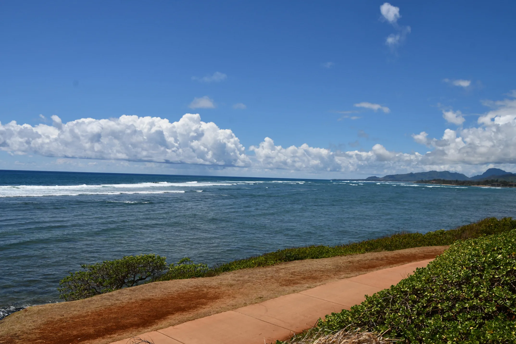
Preserving a Coastline for the People
The vision for Ke Ala Hele Makalae first took root back in the 1990s. At that time, Kauaʻi's visitor industry was expanding rapidly after years of economic uncertainty following the decline of agriculture. Resort facilities were being developed along prime coastal areas. A very real fear emerged within our tight-knit community that public access to the shoreline could be lost forever to private development.
This wasn't just about losing places to exercise or enjoy weekend picnics. This threatened the very foundation of our culture. Traditional and customary practices like fishing, gathering limu (seaweed), and connecting with the ocean that have sustained our people for countless generations were at risk. The ocean isn't just our backyard here on Kauaʻi. It's part of our identity, our sustenance, and our spiritual connection to this place.
Community leaders and visionaries stepped forward with courage and determination. Former Mayor Maryanne Kusaka first envisioned the path as a way to enhance the physical and mental well-being of our keiki (children), kūpuna (elders), and families of all backgrounds.
Her vision was carried forward with passion and persistence by former Mayor Bryan Baptiste, who understood that the path was crucial for securing public coastal access in perpetuity. They understood something fundamental that guides us to this day. The coast belongs to everyone. Not just resort guests or wealthy property owners, but every person who calls Kauaʻi home and every visitor who comes here seeking the healing power of the ocean. Their remarkable foresight and political courage is the reason we can all enjoy this unbroken stretch of paradise today.
From Sugarcane Rails to Bicycle Trails: Honoring Our Agricultural Heritage
What many people don't realize as they cruise along the smooth pavement is that when you ride on certain sections of Ke Ala Hele Makalae, you're actually tracing the footsteps of history. You're following paths that workers walked and trains traveled over a century ago. Parts of the path are built directly on the former roadbeds of the Ahukini Terminal & Railroad Company.
Back in the bustling 1920s, this railway system was the vital artery of the island's sugar industry. Day after day, trains would haul freshly cut sugarcane from the sprawling Līhuʻe Plantation and Makee Sugar Company fields to the port for shipping to markets around the world. The railroad represented prosperity, jobs, and a way of life that defined Kauaʻi for generations.
As the sugar industry gradually faded through the latter half of the 20th century, these "haul cane corridors" fell into disuse and disrepair. Weeds grew over the tracks. The infrastructure that once connected our communities began to crumble. But the path's visionary creators saw incredible potential to transform these remnants of our old economy into a valuable asset for our new one. An economy based on sustainable tourism, community health, and preserving the natural beauty that makes Kauaʻi special.
The symbolism is powerful when you think about it. Where sugar once traveled to feed the world, families now travel to feed their souls. Where economic activity once flowed primarily to benefit distant corporations, community activity now flows to benefit all of us who call this island home.
A Phased Approach to Building a Dream: Decades of Determination
Creating Ke Ala Hele Makalae was a monumental task that required patience, persistence, and careful planning. The project was broken into an ambitious six-phase plan under Mayor Kusaka's forward-thinking administration. It has been a multi-decade effort involving federal funding, county government resources, and the tireless advocacy of dedicated community groups like Kauai Path, Inc.
📍 Phase I: The Foundation (2003)
The journey began at Lydgate Park, where families had been gathering for generations. The first 2.5-mile section was completed in 2003, creating a safe, paved connection along some of the most family-friendly coastline on the island. This initial segment proved the concept and showed skeptics that the path could enhance rather than disrupt our coastal environment.
🌟 Phase II: The Backbone (2009)
This crucial four-mile stretch from Kapaʻa north to Kuna Bay (Donkey Beach) opened in 2009 after years of careful planning and construction. It was built largely on those historic old haul cane routes, which had been generously donated to the county by developers who understood the community benefit. This phase created the scenic backbone of what many consider the most beautiful section of the entire path.
🌉 Phase III: The Challenge (2017)
Connecting the first two phases proved to be the most technically difficult and politically complex part of the entire project. It involved intricate property acquisitions in densely populated residential areas. Engineers had to navigate sensitive environmental concerns and respect cultural sites along the sacred Wailua Beach area. The major triumph of this phase was the construction of the remarkable 1,500-foot Kawaihau Elevated Boardwalk in 2017. This engineering marvel represents years of planning and millions of dollars in investment. It connects the most densely populated residential area on the entire island directly to the coast, allowing families to safely walk or bike from their homes to the ocean without dealing with dangerous highway traffic.
The Vision for Tomorrow: A 17-Mile Coastal Artery
The dream for Ke Ala Hele Makalae is far from complete, and that's what makes it so exciting. The ultimate vision is a continuous 17-mile coastal artery stretching from Nāwiliwili Harbor in the south all the way to the rural community of Anahola in the north. When completed, it will create an unbroken ribbon of public access along the most spectacular coastline in Hawaii.
Future Southern Extension (Phases IV & VI): Connecting to Līhuʻe
The next major step in this grand vision is to connect Lydgate Park south through the historic town of Hanamaʻulū all the way to Līhuʻe, our county seat. This extension would open up access to Kalapakī Beach, one of Kauaʻi's premier family beaches, and provide a safe route for residents and visitors staying in the Līhuʻe area.
The most exciting and historically significant part of this plan involves restoring and repurposing the beautiful Hanamaʻulu Bridge. This graceful concrete arched bridge was originally built for the railway system in the 1920s. It has been abandoned and slowly deteriorating for over 50 years, a haunting reminder of our agricultural past.
Rather than demolish this piece of history, the plan calls for carefully restoring it as a pedestrian and bicycle bridge. Imagine cycling across this historic span, with views of Hanamaʻulu Bay stretching out below you. It would create one of the most Instagram-worthy and culturally significant moments on the entire path.
As of early 2024, this phase is tantalizingly close to moving forward. The project is awaiting a final response from the State Historic Preservation Division, which must approve any work on the historic bridge. Once that approval comes through, construction could begin on what will undoubtedly be the most photogenic section of the entire path system.
Future Northern Extension (Phase V): The Final Frontier
The final piece of this ambitious puzzle involves extending the path from its current northern terminus at Donkey Beach to the rural community of Anahola. This section would traverse some of the most rugged and undeveloped coastline on the island, offering riders and walkers an authentic taste of old Kauaʻi.
Anahola represents the heart of Native Hawaiian rural life on Kauaʻi. It's a place where families still practice traditional fishing and farming, where Hawaiian is spoken in daily conversation, and where the pace of life reflects island values rather than tourist expectations. Connecting this community to the path system would provide economic opportunities while preserving its unique character.
Unfortunately, this section is currently on hold due to extremely complex land-rights issues involving both private landowners and Hawaiian Homelands. The project awaits the political will and creative problem-solving necessary to move forward. While it may be years away, knowing the full scope of the vision gives you a complete picture of this incredible community project.
As someone who rides this path almost daily, my top tip is to appreciate not just the stunning ocean views, but the remarkable journey it took to create them. Every smooth section of pavement represents years of planning, community meetings, environmental studies, advocacy, and collaborative effort. It's a testament to what's possible when a community decides to fight for something truly valuable.
📅 Timeline
- 1990s: Vision begins
- 2003: Phase I opens
- 2009: Phase II opens
- 2017: Phase III opens
- Future: 17-mile dream