Kilauea Summit
The heart of the volcano - where creation and destruction meet
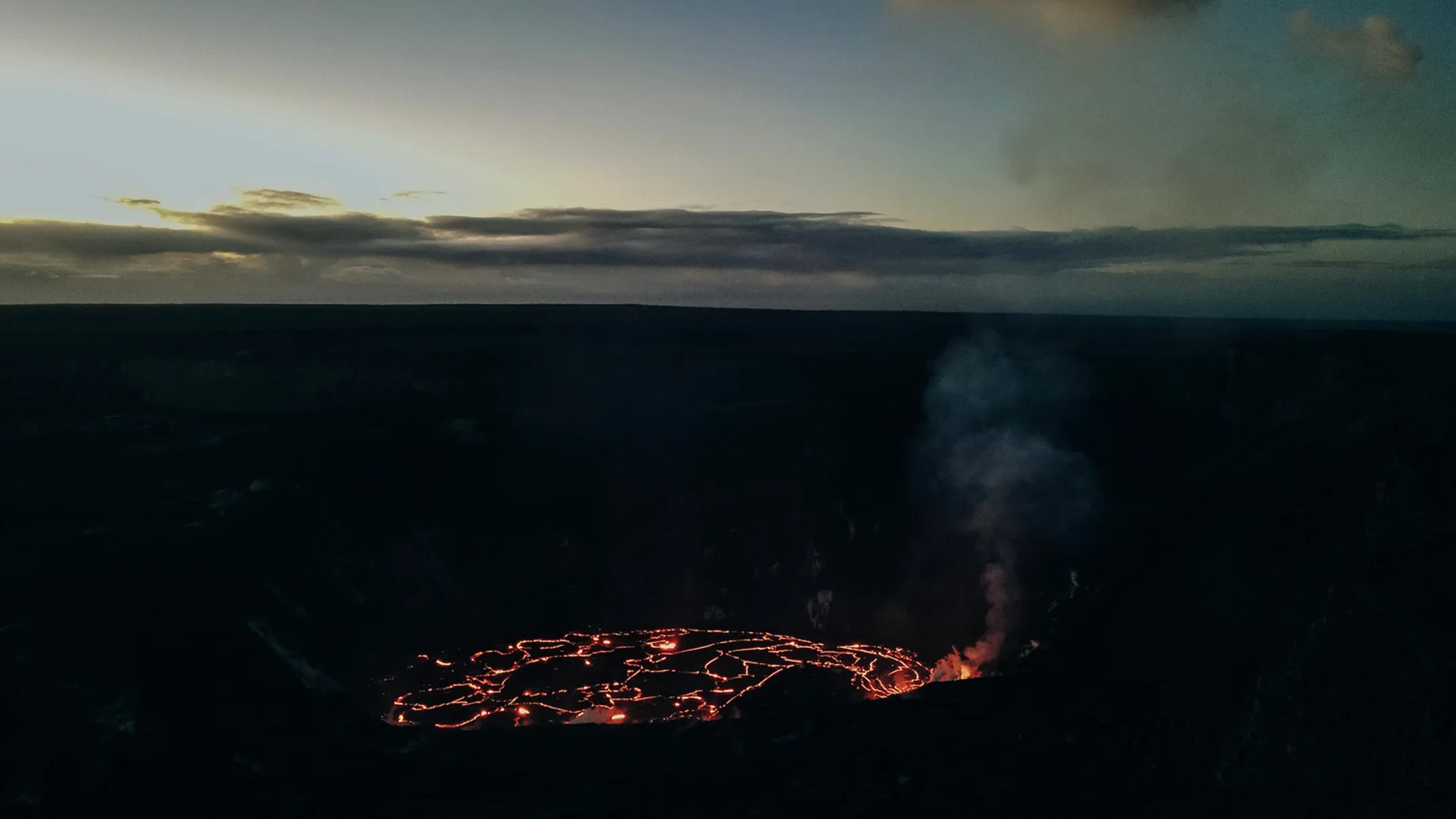
Exploring Kilauea Summit: The Heart of the Volcano
The summit area gives you the best access to Kilauea's power. Here you smell sulfur on the wind. You feel heat rising from steam vents. You see the stark beauty of land recovering from fire. You walk through ancient lava tubes where Hawaiian stories echo.
This isn't just about geology. It's about walking through the life cycle of our volcano. Creation, destruction, and rebirth happen all around you.
The summit sits at 4,000 feet elevation. Expect temperatures 12-15 degrees cooler than the coast, frequent rain, and rapidly changing conditions. Come prepared for all weather.
Crater Rim Drive: Your Journey Through Pele's World
10.6-Mile Loop Around Kilauea Caldera
The 10.6-mile Crater Rim Drive loops around Kilauea's caldera. This paved road is your main route to the best views and trails. It takes you from thick, misty rainforest to sun-baked desert in minutes.
Drive clockwise from the Welcome Center for the best experience:
Kilauea Overlook & Uekahuna
Sweeping views across the massive caldera and into active Halemaumau crater. Uekahuna used to house the Jaggar Museum. Now it's an open-air deck where you connect directly with the volcanic landscape.
Kukamahaukea (Steam Vents)
Feel the volcano's inner heat. Steam rises from the ground where rainwater meets hot underground rocks. A short path lets you get close to this geothermal display.
Kilauea Iki Overlook
Shows you the "Little Kilauea" crater with its solid lava lake that still steams. This is also where the famous Kilauea Iki trail begins.
Puu Puai Overlook
"Gushing hill" - this massive cone formed when the 1959 Kilauea Iki eruption shot lava fountains high into the air. See across the crater and imagine the incredible force that built this hill.
The Kilauea Iki Trail
Walking Across a Frozen Lava Lake
This trail might be the park's most famous hike, and for good reason. It takes you from lush rainforest down to the floor of a crater that was a lake of molten rock just decades ago.
The trail starts on the crater rim in thick forest filled with native birds and giant hapuu tree ferns. This feels like old Hawaii, before people changed so much. The path drops 400 feet down rocky switchbacks to reach the crater floor.
Walking on Another Planet
Stepping onto Kilauea Iki's floor is like walking on another planet. A vast black lake of solid lava stretches before you. Steam still rises from cracks in the rock. In 1959, this crater was a cauldron of fire for five weeks. Lava fountains shot 1,900 feet high, creating the lake you now walk across.
Trail Details
Distance & Time
3.3-mile loop, 2-3 hours, moderate to challenging difficulty
Required Gear
Sturdy shoes that cover your feet - lava rock is sharp and uneven
Follow the Cairns
Stone cairns (ahu) mark the safe trail across the crater floor - they're not decorations
Look for the "Bathtub Ring"
Marks on crater walls show how high the lava lake rose before draining
Parking Pro Tip
Parking at Kilauea Iki fills up fast. Try parking at the Devastation Trailhead instead. From there, you can do a longer 6-mile loop that includes Devastation Trail, Nahuku, and Kilauea Iki. This solves the parking problem and gives you more of the summit experience.
Nahuku (Thurston Lava Tube)
Walking Through Lava's Underground Highway
A short walk through fern forest leads to Nahuku, a 500-year-old lava tube that shows you how volcanoes work inside. Lava tubes form when the outside of a lava river cools and hardens while hot rock keeps flowing underneath. When the flow stops and drains out, it leaves a hollow tunnel.
The Hawaiian name Nahuku means "the protuberances." This probably refers to lava stalactites that once hung from the ceiling. Sadly, souvenir hunters stripped these away after the tube became famous in 1913.
Nature's Recovery
Now different beauty has returned. During the closure after 2018, roots from ohia trees growing above broke through the ceiling. White colonies of tiny life forms grew on the damp walls. These are part of a fragile ecosystem. Don't touch the walls or hanging roots.
Visiting Information
Trail Details
- • Easy 0.4-mile loop
- • Lit from 8 a.m. to 8 p.m. daily
- • Bring flashlight for after-hours visits
- • Small parking area fills quickly
Alternative Access
- • Park at Kilauea Iki Overlook
- • Take 0.5-mile trail along crater rim
- • Visit before 9 a.m. or after 4 p.m.
- • Combine with other summit trails
Devastation Trail
Nature's Comeback Story
The Devastation Trail teaches a powerful lesson about recovery. This 1-mile paved path isn't about destruction. It's a living classroom showing how nature heals itself.
The trail crosses land buried under hot cinder and ash during the 1959 Kilauea Iki eruption. The ohia forest was incinerated, leaving a moonlike landscape.
The Slow Return
Today you walk through this recovering world and see nature's slow return. Bleached skeletons of ohia trees stand like monuments to the forest that was. Hardy plants, including new ohia saplings, push up through the black cinder, adding green to the dark canvas.
Accessibility
The paved path makes this trail accessible to wheelchairs and strollers. Some sections are steeper than eight percent and might need assistance.
Wildlife Alert
Home to nene, our endangered Hawaiian goose. Drive carefully and never feed the wildlife. Feeding nene makes them dependent on humans and cars.
🏃 Trail Difficulty
🅿️ Parking Tips
High Traffic
Kilauea Iki, Nahuku fill fast
Best Times
Before 9 AM, after 4 PM
Alternative
Devastation Trailhead for loops
🌤️ Summit Weather
- 4,000 feet elevation
- 12-15°F cooler than coast
- Frequent rain & mist
- Rapid weather changes
- Strong UV at altitude
📍 Must-See Stops
Kilauea Overlook
Best crater views
Steam Vents
Feel the heat
Kilauea Iki Floor
Walk on lava lake
Nahuku Tube
Underground journey