Trail Guides
Step-by-Step Directions for All 3 Sleeping Giant Trails

Written by a Local Hiking Expert
Kalani MillerNounou East Trail: The Classic Ascent
This is the trail I recommend for most visitors and anyone chasing that iconic Kauaʻi sunrise. It's a steady climb, but every switchback reveals a little more of the coastline, building anticipation for the final reward. It's the perfect introduction to the giant.
Getting There
The trailhead sits at the end of Haleilio Road in Wailua. From Kūhiō Highway (Hwy 56), turn inland at the traffic light by the Shell gas station. Follow Haleilio Road for about a mile until you reach the trailhead parking area on the right. The lot is small, fitting only about 15 cars, so I strongly advise arriving very early, especially if you're aiming for sunrise. Please be quiet and respectful of the residents in this neighborhood.
The Hike, Step-by-Step
The Trailhead and First Switchbacks (Miles 0 - 0.5)
The adventure begins to the right of the parking lot, where the trail immediately starts its ascent. You'll climb through a series of well-maintained switchbacks that moderate the grade. The path cuts through a forest of introduced trees like ironwood, silk oak, and the ever-present strawberry guava. If they're in season (typically summer), feel free to sample the small, tart, red fruits—they're a delicious trailside treat.
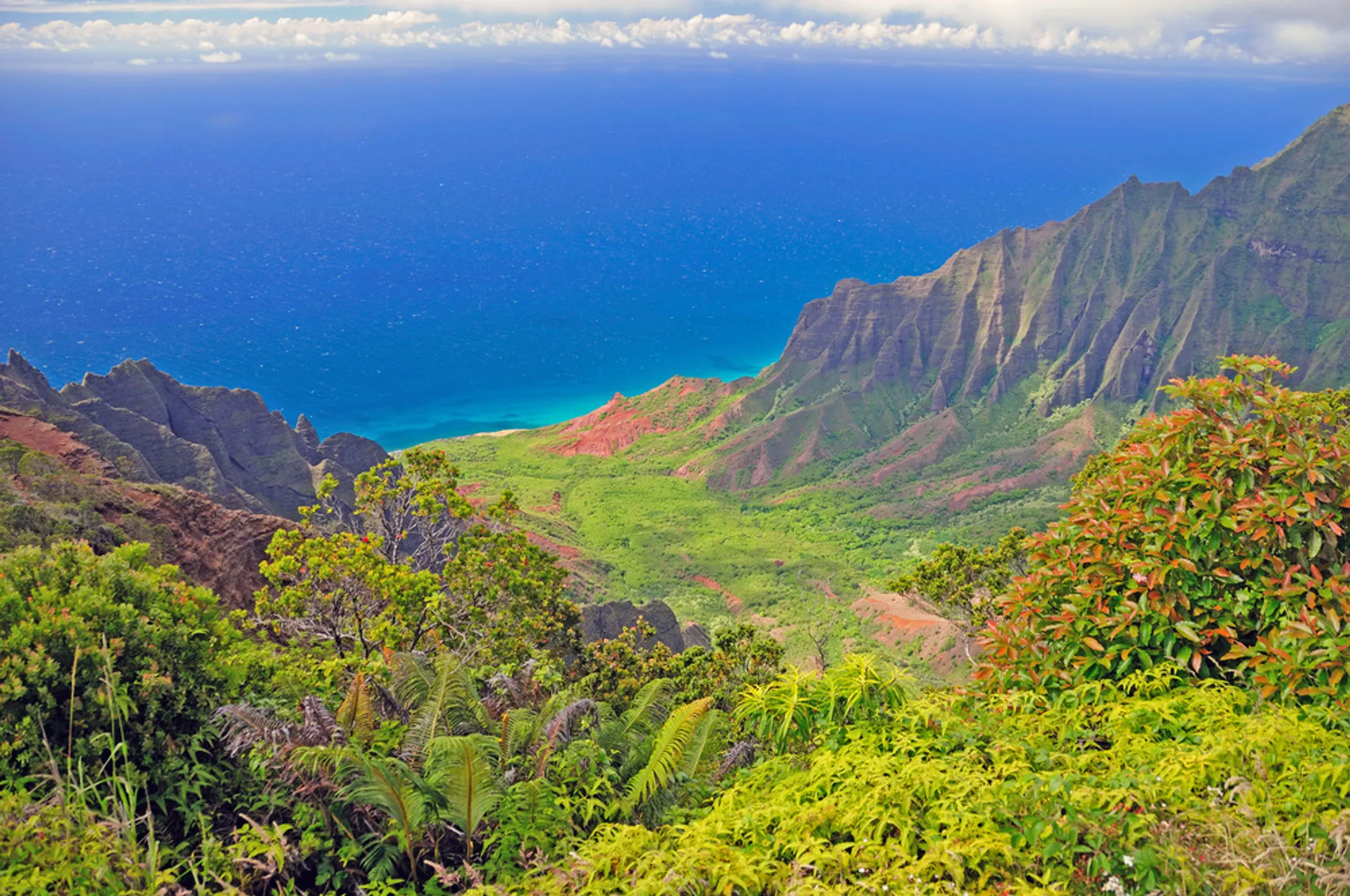
The First Vistas (Mile 0.5 - 1.0)
After the initial climb, the trail flattens out for a short reprieve. Here, you'll find the first clearings in the trees, offering tantalizing glimpses of the Pacific Ocean and Kapaʻa town below. A little further up, you'll come across a beautifully carved bench with "Respect Kauai" etched into it. This is a perfect spot for your first water break and a great photo opportunity.
The morning light filtering through the canopy creates a cathedral-like atmosphere. Wild roosters often crow from hidden perches, their calls echoing through the valley. This section teaches patience—each step reveals new angles of the coastline, but the best views are still ahead.
The Junctions (Mile 1.4 - 1.5)
The trail system has several intersections, so paying attention here is key. At about 1.4 miles, you'll reach a fork where the Kuamoʻo-Nounou Trail merges from the left. Stay on the main, more-traveled path to the right. Shortly after, the Nounou West Trail joins from your right. At this major junction, you will go left to continue towards the picnic shelter and the summit.
These junctions can confuse first-time hikers. Look for the worn path with the most foot traffic—that's usually the correct route. The trails converge here because this is where the giant's body parts meet, creating natural ridgelines that early trail builders followed.
Reaching the "Chest" (Mile 1.6)
The trail leads to a covered picnic shelter, a landmark you can't miss. Congratulations, you've reached the giant's chest! For many hikers, this is the destination. The views of the Wailua River Valley snaking through the landscape are breathtaking. You'll likely be greeted by a welcoming committee of local chickens (moa), who are experts at begging for snacks. As always, please admire them but do not feed them.
From this vantage point, the sacred nature of Wailua becomes clear. The river winds like a silver ribbon through green pastures, connecting the mountains to the sea. Ancient Hawaiian settlements once dotted this valley, and you can almost feel their presence in the quiet morning air.
Nounou West Trail: The Steeper Challenge
The West trail is my choice for a quick, heart-pumping hike. It's shorter but noticeably steeper than its eastern counterpart, and the reward is walking through a breathtaking cathedral of Cook Pines at the beginning. It feels ancient, quiet, and like you've been transported to another world.
Getting There
One of the big advantages of the West Trail is easier parking. There are multiple access points, making it less competitive than the East Trail lot. The primary trailheads are at the very end of Lokelani Road and along Kamalu Road (near mile marker 2) in the Wailua Homesteads. I find the Lokelani Road entrance to be the most direct and scenic start.
The Hike, Step-by-Step
The Cathedral of Pines (Start)
The experience of this trail begins the moment you step out of your car. The path starts alongside a residential fence—please be mindful of the neighbors—and quickly enters a magical grove of towering Cook Pines. These tall, slender trees create a stunning canopy that filters the sunlight, making for an unforgettable start and a fantastic photo opportunity. This pine forest is the signature feature of the West Trail.
Walking through these pines feels like entering a natural cathedral. The trees stretch impossibly high, their trunks perfectly straight, creating columns that seem to support the sky. Morning mist often clings to their branches, adding to the mystical atmosphere. This forest was planted by the Civilian Conservation Corps in the 1930s, but it feels timeless.
The Ascent and Junctions
After the serene forest, the work begins. The trail becomes a much steeper and more direct climb than the East trail, gaining elevation quickly. A common mistake I see hikers make is underestimating this section, especially after a rain. The path can become extremely muddy and slick, so proper footwear is non-negotiable.
You'll soon come to a junction where the Kuamoʻo Trail merges from the right. Stay left to continue your ascent up the mountain. The path eventually meets the East Trail at the main junction. From here, turn right to make your way to the picnic shelter on the giant's chest.
This steep section demands respect. The red dirt of Kauaʻi becomes treacherous when wet, turning into a clay-like surface that can feel like ice. Use tree roots and rocks for handholds. Take breaks when needed—there's no shame in pacing yourself. The reward at the top makes every challenging step worthwhile.
Kuamoʻo-Nounou Trail: The Scenic Ridge
⚠️ Critical Safety Update
Let's talk about the Kuamoʻo trail. While it's a beautiful, gentle hike, your safety is my top priority. Multiple sources, including recent hiker reports, indicate that the wooden bridge over Opaekaa Stream at the start of this trail is CLOSED and the trail is inaccessible. Attempting to cross a damaged bridge or find an alternate route could be extremely dangerous.
This situation highlights a crucial point for any adventure in Hawaiʻi: conditions change, and online information can be outdated. Official sources are not always perfectly up-to-date with real-time, on-the-ground conditions, creating a hazardous information gap for visitors. The most responsible advice I can give you is to teach you how to verify trail status for yourself.
Before attempting this or any hike, I urge you to check the official Nā Ala Hele Trail and Access Program website and look for any alerts or news releases from the Department of Land and Natural Resources (DLNR) for Kauaʻi. This is the best way to ensure you have the most current information.
For Future Reference (If/When the Bridge is Repaired)
Should the bridge be repaired and the trail officially reopened, here is what you can expect:
The trailhead is found on Kuamoʻo Road (Hwy 580). The hike begins by crossing the wooden bridge over Opaekaa Stream. The trail is a gentle, shaded walk through a lush forest canopy. It is less about dramatic, sweeping views and more about enjoying the solitude and quiet beauty of the ridge.
At about the 0.75-mile mark, you'll find a picnic shelter with pleasant views of Kalepa Ridge. The trail continues until it intersects with the Nounou West Trail within the impressive Cook Pine forest, where you would turn left to continue to the summit.
This trail offers a different perspective of the giant—approaching from behind, so to speak. The forest here is denser, more humid, with the sound of running water often audible through the trees. Native plants are more common along this route, making it a botanist's dream when accessible.
🗺️ Trail Quick Reference
📍 Trailhead Locations
- East TrailEnd of Haleilio Road, Wailua~15 car parking
- West TrailLokelani Rd or Kamalu RdBetter parking options
- Kuamoʻo TrailKuamoʻo Road (Hwy 580)Bridge currently closed
🧭 Navigation Tips
- Follow most-worn path at junctions
- All trails converge at picnic shelter
- Look for "Respect Kauai" bench on East
- Download offline map before hiking